
Block 04 of 11 · Report SSRC-TER-LG-01 · Version 2.2
Volcanoes, Aquifers, Karst and Ground Hazards
Actual relationship between earthquakes and volcanoes, regional volcanic situation, wells, karst, liquefaction, landslides and tsunami.
9. Earthquakes and Volcanoes: Real Relationship and Limits
| CORE IDEA. Volcanic earthquakes are common within magmatic systems; tectonic earthquakes only trigger some volcanic responses and generally require a previously critical volcano. |
|---|
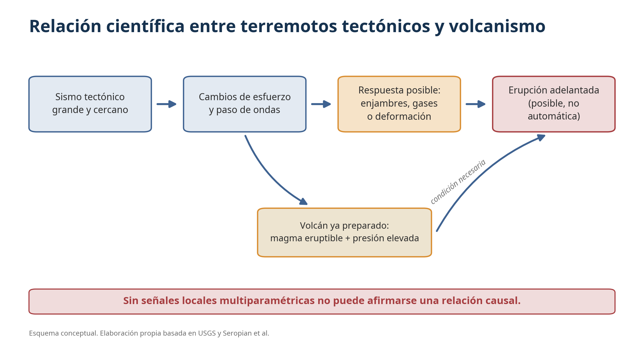
Figure 10. Conditions necessary to attribute a possible volcanic response to an earthquake. Own elaboration based on USGS and Seropian et al. [12-13].
The first relationship is direct: magma ascent, gas pressure, and hydrothermal circulation fracture rock and generate volcano-tectonic earthquakes, long-period events, and tremor. A swarm beneath a volcano does not, by itself, imply an eruption; observatories combine seismology with GPS/tilt deformation, gases, temperature, imaging, and satellite observation.
The inverse relationship—a tectonic earthquake modifying a volcano—is possible. Dynamic waves can agitate fluids, mobilise bubbles, or unblock fractures; static stress changes act near the rupture. The USGS emphasises that the most convincing cases involve regional earthquakes greater than magnitude 6 and volcanoes that already have eruptible magma and sufficient pressure [12].
Possible responses include a brief increase in microseisms, changes in thermal springs, gases, or deformation. Attribution requires demonstrating that the signal exceeds background variability, appears with a physically reasonable latency, and is not better explained by the volcano's own evolution. The coincidence of dates is a starting point, not proof.
The review by Seropian and collaborators proposes evaluating prior state, distance, wave amplitude, static changes, mechanism, and temporal chain. Even when activation occurs, the earthquake may accelerate a process that would have happened anyway. Public communication must avoid "the earthquake woke up all the volcanoes."
Local monitoring is decisive. A volcano hundreds or thousands of kilometres away that maintains its background parameters is not considered activated just because it felt waves. Similarly, a real change in Puracé must be interpreted with its Colombian network, not with the seismic catalogue of La Guaira.
10. Regional Volcanic Situation in August 2026
| CENTRAL IDEA. There are no Holocene volcanoes recognised as active in continental Venezuelan territory; the relevant regional foci are in Colombia and the Lesser Antilles arc. |
|---|
On August 7, 2026, the Colombian Geological Survey (Servicio Geológico Colombiano - SGC) maintained the Puracé-Los Coconucos volcanic chain on orange alert. Long-period seismicity and continuous tremor associated with fluids less than 1 km beneath the crater persisted. Rock fracturing was low, SO2 flux was estimated at 1,900 tonnes per day, soil CO2 was increasing, and an ash emission had been recorded. The SGC warned that a temporary decrease does not imply a return to stability and recommended not approaching the craters [10].
This activity had shown changes before and after June and is part of the Puracé system's inherent dynamics. To claim that the Venezuelan doublet triggered it would require a specific study of arrival times, amplitudes, changes relative to baseline, and mechanisms. The SGC bulletin does not establish such causality; neither does this report.
In the Eastern Caribbean, La Soufrière of St. Vincent was at green level according to UWI-SRC, while Kick-'em-Jenny maintained its ordinary maritime exclusion zone. Soufrière Hills in Montserrat continues under surveillance. Alert levels describe the state of each system and are not directly comparable if national scales differ.
The Smithsonian Global Volcanism Program indicates that there are about 40-50 continuous eruptions at any given time and that no global increase in volcanic activity is observed. Between 2000 and recent years, the number of volcanoes erupting annually varies within an expected range; improved satellites and communications make previously ignored remote episodes visible [11].
For Venezuela, direct volcanic hazard is much lower than seismic hazard, but ash from Colombian or Caribbean eruptions can affect aviation, health, and services depending on wind and column height. Tsunamis of volcanic origin, though rare, are part of the context of Kick-'em-Jenny and the island arc.
| System | Status at cut-off | Indicators | Interpretation |
|---|---|---|---|
| Puracé-Los Coconucos, Colombia | Orange | LP, tremor, high SO2, CO2 in soil, ash | Significant change; daily SGC monitoring. |
| La Soufrière, St. Vincent | Green | Background parameters reported by UWI-SRC | No public signs of crisis at cut-off. |
| Kick-'em-Jenny, Grenada | Normal system yellow | Monitored submarine volcano; 1.5 km exclusion | Main risk for nearby navigation. |
| Soufrière Hills, Montserrat | Continuous monitoring | Long-duration active system | Follow MVO/UWI-SRC; do not infer from Venezuelan earthquakes. |
| Continental Venezuela | No active Holocene volcanic arc | Local thermal/geological manifestations | Do not confuse hot springs or mud volcanoes with eruptive magmatism. |
11. Aquifers, Wells, and Hydrogeochemical Changes
| CORE IDEA. Earthquakes can temporarily or persistently modify water levels and quality; the response is local, heterogeneous, and controlled by fractures, confinement, distance, and wave frequency. |
|---|
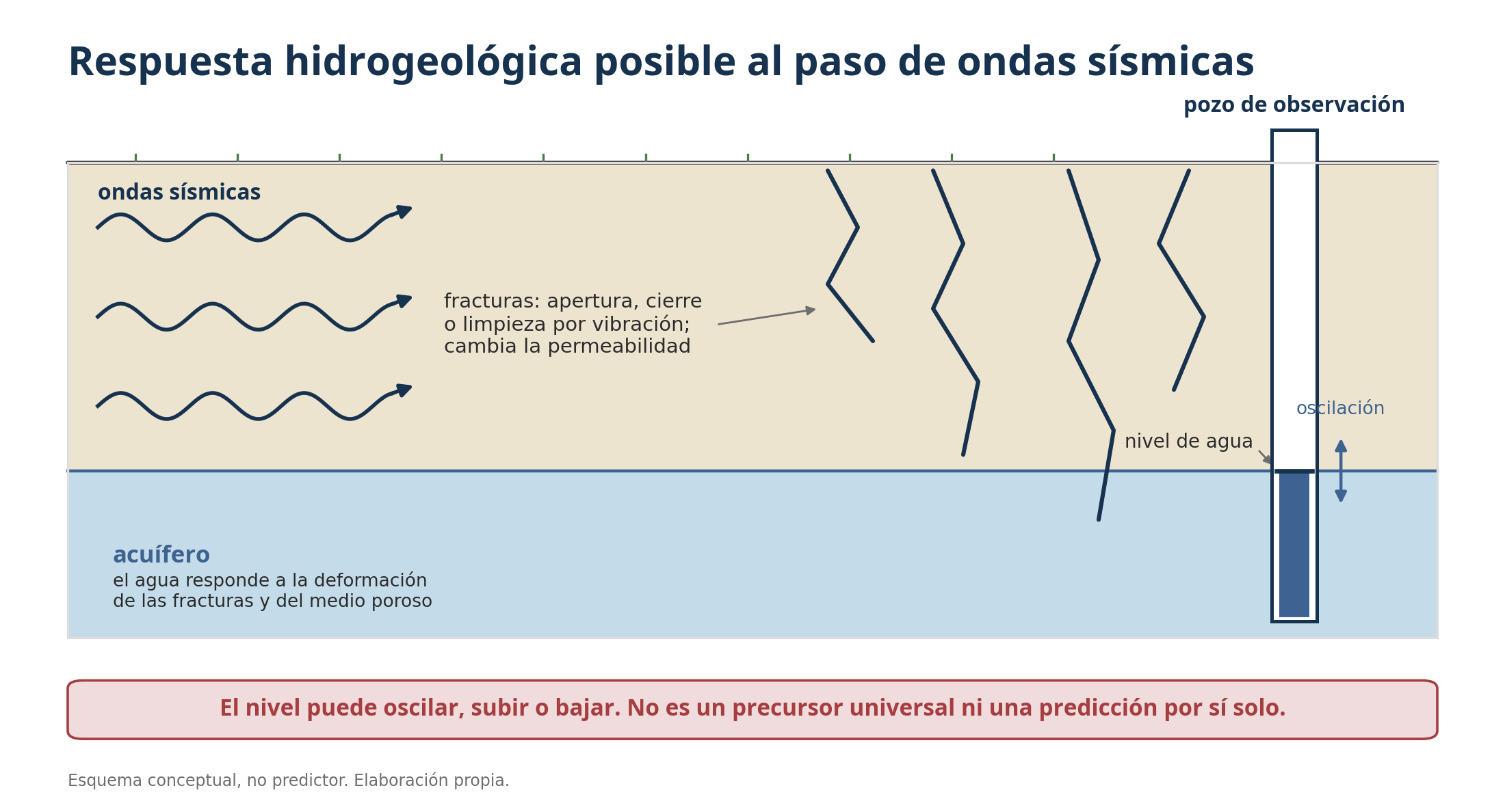
Figure 11. Mechanisms of aquifer response to wave passage. Conceptual diagram, not predictive.
A well acts as a pressure sensor. Waves deform the aquifer and can cause the water column to oscillate for minutes. The USGS has observed responses thousands of kilometres away for large earthquakes, although most return to their previous level. Other wells show a lasting displacement if permeability or gradient changes [14-15].
Shaking can open, close, or clean fractures, mobilise fines, and connect compartments. The result can be a rise or fall: there is no universal direction. Spring flow, turbidity, temperature, conductivity, radon, ions, or gases also change. Many of these parameters also respond to rain, drought, pumping, earth tides, atmospheric pressure, construction work, or sensor failures.
In karstic terrain, conduits and fissures transmit water rapidly. A small disturbance can divert flow to another spring, empty a local storage, or introduce sediments. The literature records seismic hydrogeochemical responses but acknowledges mechanisms that are still uncertain [16]. A decline observed after an earthquake may be a consequence of drainage through new fractures; before an earthquake, it may coincide due to ordinary causes.
To assess an anomaly, a continuous series prior to the event, control wells, rainfall and pumping data, barometric and tidal correction, calibration, statistical analysis, and a physical hypothesis are needed. A photograph of a low well or the testimony "the spring disappeared" does not allow dating or locating a future earthquake.
After the shaking, the immediate problem is sanitation. Sewerage breaks, surface ingress through damaged wellheads, cracks, and loss of pressure can contaminate water. Suspicious abstraction points must be isolated, microbiology and chemistry analysed, disinfected according to the health authority, and alternative supply provided.
Minimum protocol for a change in a well or spring
Record date, time, level, flow, turbidity, odour, temperature, and take photographs without exposing oneself to cavities or slopes.
Check for rain, pumping, electricity, pipe breaks, and recent construction work.
Compare with other points and with the baseline, avoiding conclusions based on a single data point.
Suspend consumption if there is turbidity, odour, wellhead damage, or possible ingress of wastewater.
Notify the operator, water authority, public health, and hydrogeological team.
Maintain monitoring; do not disseminate unvalidated seismic prediction messages.
12. Karst Terrain, Subsidence, and Cavities
| CORE IDEA. Karst increases hydrogeological sensitivity and the risk of localised collapse, but it does not turn every crack or water descent into a seismic signal. |
|---|
Karst develops when slightly acidic water dissolves soluble rocks, mainly limestones, dolomites, gypsum, and salt. It produces lapies, dolines, sinkholes, caves, conduits, and highly heterogeneous aquifers. In Venezuela, carbonate formations and karstic landscapes exist, although La Guaira is dominated in large areas by metamorphic rocks and fractured massifs; the label "karstic" must be cartographically verified for each location.
A tremor can dislodge blocks from cave ceilings, destabilise rock bridges, redistribute sediments, or facilitate the collapse of an already critical cavity. The risk increases with saturated residual soils, shallow voids, water leaks, excavation, new loads, or a rapid drop in the water table that removes hydraulic support.
Excessive water extraction can compact sediments and promote subsidence. In karst, piezometric drawdown can accelerate collapses if the material covering a cavity loses buoyancy or is washed away. However, this chain of events requires local conditions and should not be generically invoked to explain tectonic damage.
Cracks after an earthquake can have several causes: tectonic deformation, differential settlement, liquefaction, landslide, soil shrinkage, fill failure, or foundation failure. A geologist or engineer must map orientation, continuity, aperture, displacement, and relationship with topography and structures.
In emergencies, a new doline, subsidence, subterranean sound, sudden water loss, or concentric cracks justify cordoning off and evacuating the vicinity. One should not enter caves, wells, or collectors after a tremor due to the risk of collapse, gases, flooding, and aftershocks.
| Observation | Possible Hypotheses | Prudent Action |
|---|---|---|
| Well level drops rapidly | Drainage due to fracture, pumping, leak, drought, measurement error | Verify instrument and pumping; sample and compare. |
| Turbid water | Mobilisation of fines, surface ingress, sanitary rupture | Do not consume; authorised analysis and disinfection. |
| Doline or subsidence | Cavity, broken pipe, poor backfill, subsidence | Cordon off; urgent geotechnical evaluation. |
| Crack on slope | Landslide, settlement, erosion or surface rupture | Stay away from the slope; monitor rain and movement. |
| Spring flow increases | New connectivity, rain, pipeline rupture | Measure flow and chemistry; do not attribute without controls. |
13. Liquefaction, Landslides, Tsunami and Flooding
| CENTRAL IDEA. Shaking is the trigger; terrain and water determine many of the secondary damages. |
|---|
Liquefaction occurs when loose, saturated granular sediments lose strength due to increased pore pressure during loading cycles. It can produce sand volcanoes, settlements, lateral spreading, flotation of pipelines, and foundation failure. Coastal fills, alluvial fans, and riverbanks require attention; not all sand liquefies, and analysis depends on density, grain size, water table level, and seismic demand.
Landslides include rockfalls, shallow or deep landslides, and debris flows. After a large earthquake, rain becomes a multiplier. Danger signs are new cracks, tilted trees, bulges, new springs, noises, falling stones, and streams that become turbid or stop flowing. The USGS warns that removing a blockage can reactivate the mass and conceal power lines [3].
An underwater or coastal earthquake can generate a tsunami if it vertically displaces the seabed, triggers an underwater landslide, or causes a mass to collapse into the sea. Pure strike-slip faults are less efficient, but vertical components and local landslides do not rule out small or very close waves. On the coast, strong or prolonged shaking is a natural signal to evacuate to higher ground without waiting for confirmation.
The international reference recommendation is, after taking cover during the shaking, to move to high ground and inland if one is near the sea and the shaking was strong or lasted around 20 seconds or more. Generic distances do not replace local maps. In La Guaira, nearby mountains offer height, but narrow access routes and unstable slopes require previously studied routes and evacuation on foot when possible.
Flooding can result from the rupture of reservoirs, pipelines, dikes, landslide dams, or blocked watercourses. The absence of a natural dam in reviewed images does not rule out sectors hidden by clouds. Suddenly reduced downstream flows and upstream impoundments should be monitored.
| COMPOUND RISK. In La Guaira, the best decision may change depending on the dominant hazard: during shaking, cover is sought; afterwards, a damaged building requires an orderly exit; on the coast with a tsunami warning, height is gained; facing an active slope, both the toe and the path of the landslide are avoided. |
|---|