
Block 00 of 11 · Report SSRC-TER-LG-01 · Version 2.2
Framework, method and executive summary
Methodological disclaimer, levels of evidence, executive summary, study objective and seismology fundamentals.
Methodological and Safety Warning
| LIVING DOCUMENT. The 2026 sequence and its consequences continue to evolve. Casualty figures, aftershocks, damage, and alerts may be revised. Warnings from FUNVISIS, Civil Protection, local authorities, seismological centres, and volcanic observatories always take precedence. |
|---|
This report integrates instrumental, historical, geological, hydrogeological, and civil protection information. It does not replace a structural, geotechnical, or hydrogeological assessment of a specific building or site. Nor does it provide a prediction of future earthquakes. Current science allows for identifying sources, estimating hazards, developing scenarios, and issuing early warnings after rupture initiation, but not precisely determining the date, location, and magnitude of a large earthquake in advance [17].
References to drops or rises in well levels, changes in flow rate, turbidity, temperature, gases, or chemical composition are treated as hydrogeological responses that may accompany or follow ground shaking. Some precursor changes have been described in particular cases, but there is no unique, reproducible, and sufficiently reliable pattern to use them in isolation as an earthquake alarm.
The so-called "triangle of life" is analysed due to its social dissemination, but it is not recommended as general conduct. Guides from the USGS, CDC, and Red Cross favour "drop, cover, and hold on," remaining indoors if already inside, because running outside exposes individuals to falls, glass, facades, and falling objects [19-22].
How to Read the Conclusions
| Level | Meaning | Usage in the report |
|---|---|---|
| Confirmed | Instrumental data, direct observation, or consolidated consensus | Stated affirmatively and source cited. |
| Probable | Interpretation supported by several indications, still subject to revision | Conditions and limits are explicitly stated. |
| Possible | Physically plausible mechanism but not demonstrated for this case | Not presented as a cause. |
| Unsupported | Claim without sufficient evidence or incompatible with official guidelines | Corrected or dismissed. |
Executive Summary
| MAIN CONCLUSION. Venezuela is located on an active tectonic boundary, and the June 2026 catastrophe does not imply that the entire planet has entered an exceptional seismic or volcanic phase. It does represent an extraordinary local and national crisis, with a long sequence of aftershocks and secondary hazards that may persist for months or years. |
|---|
On June 24, 2026, a large-magnitude seismic doublet occurred in northern Venezuela. In the revised USGS solution consulted on August 8, the first event reached Mw 7.2 at 22:04 UTC, 20 km east of San Felipe; about 32 seconds later, an Mw 7.5 occurred, located 17 km west of Catia La Mar, both at about 10 km depth. Both solutions received a PAGER red alert and reached maximum instrumental intensities close to IX on the Modified Mercalli scale [1-2]. Initial versions of the locations and time interval varied; therefore, this document always identifies the consultation date and source.
La Guaira concentrated a substantial part of the impact due to the combination of intense shaking, urban exposure, vulnerable buildings, narrow coastline, susceptible fills and deposits, steep slopes of the Cordillera de la Costa, and access routes that can be interrupted by landslides. The USGS confirmed damage and burials related to slope movements in Catia La Mar and Playa Grande, blockages on coastal roads, and extensive landslides over La Guaira-Naiguatá. It warned that disturbed slopes may remain unstable for months or years, especially under heavy rains or aftershocks [3].
As of August 3, 2026, Reuters reported an official toll of 6,125 fatalities and nearly 61,000 people treated in hospitals, with only 16.5% of the debris removed. These are provisional and politically sensitive figures: they must be cited with date and attribution, without converting them into a definitive number [8].
The homogeneous analysis carried out for this report using the USGS ComCat catalog counts M≥4.5 earthquakes in a wide window of 0-15°N and 80-55°W. Between 2000 and 2025, the average was approximately 55.6 annual events; as of August 8, 2026, 39 were recorded, equivalent to an annualized rate close to the average. This does not negate the local surge: in northern Venezuela, M≥3 events detected by ComCat rose from 4 in May to 18 in June. The correct interpretation is "local increase in an aftershock sequence," not "demonstrated regional or global increase."
Venezuela does not host an active volcanic arc comparable to that of Colombia or the Lesser Antilles. Nearby volcanism is concentrated in the subduction zone of Colombia and the eastern Caribbean island arc. Puracé-Los Coconucos, in Colombia, was on orange alert on August 7, with long-period seismicity, tremor, elevated SO2, and increased CO2 in the soil; the Colombian Geological Survey does not attribute this process to the Venezuelan earthquakes [10]. Temporal correlation is not sufficient to establish causality.
Aquifers can respond to passing waves with oscillations, rises, falls, turbidity, or chemical changes. In fractured rocks and karst, small modifications in aperture or connectivity can produce striking responses. Without a baseline, rainfall, pumping, atmospheric pressure, earth tides, and instrumental control, these changes do not allow for diagnosing a future earthquake. After a disaster, the priority is to check the integrity of wells, intakes, pipes, sanitation, and potability.
Ten messages the reader should retain
Venezuela is seismic due to the complex interaction between the Caribbean and South American plates.
The 2026 doublet combined two ruptures very close in time and a prolonged aftershock sequence.
Magnitude, intensity, and damage are not synonymous: damage also depends on the ground, structure, and exposure.
La Guaira presents a multi-hazard chain: shaking, collapse, landslide, liquefaction, fire, local tsunami, and isolation.
More detected earthquakes do not always mean more tectonic energy: aftershocks and improved networks also play a role.
There is no evidence of a sustained global increase in natural earthquakes or global volcanism [11,18].
A large earthquake can disturb a nearby volcano only if the system is already close to an eruption [12-13].
Groundwater changes are real geophysical responses, but not a universal seismic clock [14-16].
Indoors, the general conduct is to drop, cover, and hold on; do not run during shaking.
Risk reduction depends more on safe buildings, inspection, land-use planning, communication, and drills than on seeking isolated signals.
Table of Contents
1. Objective, Scope and Research Questions
2. Fundamentals: Magnitude, Intensity, Waves and Risk
3. Tectonic Framework of Venezuela and the Southern Caribbean
4. Seismic History of Venezuela and La Guaira
5. The June 24, 2026 Doublet
6. Damage, Aftershocks and Cascading Hazards
7. Is Seismic Activity Increasing?
8. Activity in Colombia, Brazil, Guyana and the Eastern Caribbean
9. Earthquakes and Volcanoes: Real Relationship and Limits
10. Regional Volcanic Situation in August 2026
11. Aquifers, Wells and Hydrogeochemical Changes
12. Karstic Terrain, Subsidence and Cavities
13. Liquefaction, Landslides, Tsunami and Flooding
14. Self-Protection Before, During and After
15. Triangle of Life: Critical Analysis
16. Recommendations for Homes, Centres and Communities
17. Public Communication, Rumours and Disinformation
18. Conclusions and Priorities
27. Memory, Truth and Memorial: The Right of Families to Know
28. Seismic Microzonation and Land-Use Planning
29. Frequently Asked Questions from Families and the Community
Appendices: Fact Sheets, Checklists, Data Methodology and References
1. Purpose, Scope, and Research Questions
| CORE IDEA. The report studies the earthquake as a physical phenomenon and as a social disaster: the energy released only transforms into catastrophe when it encounters vulnerable populations, buildings, infrastructure, and territories. |
|---|
The objective is to offer a comprehensive yet accessible explanation of the seismicity of La Guaira and Venezuela, to place it in its history and in the context of neighbouring countries, to assess whether the data supports the perception of an increase in seismic and volcanic activity, and to convert the evidence into practical risk reduction measures.
The primary scope includes Venezuela, with particular attention to the central coastal corridor and La Guaira. The comparative scope includes Colombia, Brazil, Guyana and, due to tectonic and maritime proximity, Trinidad and Tobago, the Lesser Antilles, Aruba, Curaçao, and Bonaire. There is no intention to equate hazards: Colombia is located next to the Andean subduction zone and possesses active volcanoes; the interior of Brazil and Guyana exhibits much lower intraplate seismicity; Trinidad is part of the deformed belt of the southern Caribbean.
The historical horizon begins with the first documented earthquakes after European colonisation and extends to 8 August 2026. Ancient events are reconstructed through chronicles, damage, and macroseismic intensities; their magnitudes and source faults have greater uncertainties than modern instrumental solutions.
The guiding questions are: what tectonic structures explain the threat? what precedents exist? what singularities did the 2026 doublet have? is there a regional trend or a local concentration of aftershocks? what nearby volcanic processes are active? how do groundwater and karst respond? what cascading hazards should be monitored? and what behaviour reduces injuries and deaths?
Method
Primary sources: FUNVISIS, USGS/ComCat, Colombian Geological Survey (Servicio Geológico Colombiano), UWI-SRC, and Smithsonian Global Volcanism Program.
Academic sources: peer-reviewed articles on Venezuelan faults, historical earthquakes, volcanic activation, and seismic hydrogeology.
Human impact: official figures disseminated by international agencies, always dated and attributed.
Temporal comparison: constant magnitude thresholds to reduce bias from improved detection.
Self-protection: recommendations from USGS, CDC, and response agencies; distinction between general behaviour and situational exceptions.
2. Fundamentals: magnitude, intensity, waves, and risk
| CORE IDEA. An earthquake has one magnitude; each location experiences a different intensity. Confusing both prevents a correct interpretation of headlines, maps, and damage. |
|---|
Moment magnitude Mw estimates the physical size of the rupture from the seismic moment, which depends on the area that slips, the average amount of displacement, and the rigidity of the rocks. The scale is logarithmic: a one-unit increase implies ten times more recorded amplitude and approximately 32 times more radiated energy [16]. Therefore, an Mw 7.5 is not just slightly larger than an Mw 6.5.
Intensity describes effects and shaking at a location. The Modified Mercalli Intensity scale ranges from I, not felt, to XII, extreme destruction. The same rupture produces high intensities near the source and lower intensities with distance, but attenuation is not uniform. Sedimentary basins, coastal fills, soft deposits, and topography can amplify certain frequencies.
P-waves compress and dilate the material and arrive first; S-waves displace perpendicularly and do not travel through liquids; surface waves usually concentrate large-amplitude and long-duration movements. Early warning systems detect the first waves after the rupture begins and can provide seconds of strong shaking anticipation in distant locations. They do not predict the earthquake: they notify of one that has already started.
Hazard is the probability or potential intensity of the phenomenon; exposure brings together people, assets, and services located in the area; vulnerability expresses their susceptibility; risk combines these components. The 2026 catastrophe shows that knowing a fault is not enough. Inventories of buildings, microzonation, soil evaluation, alternative access routes, healthcare continuity, telecommunications, and community preparedness are required.
| Concept | Question it answers | Common mistake |
|---|---|---|
| Magnitude Mw | How big was the rupture? | Calling it "Richter degrees" for any earthquake. |
| Intensity MMI | How did it shake and what effects were there here? | Assigning a single intensity to the entire country. |
| PGA/PGV | What maximum acceleration or velocity was estimated/measured? | Using them alone to predict structural damage. |
| Aftershock | What earthquake follows in the rupture zone? | Assuming it will always be small or harmless. |
| Swarm | Are there many earthquakes without a dominant mainshock? | Calling any sequence of aftershocks a swarm. |
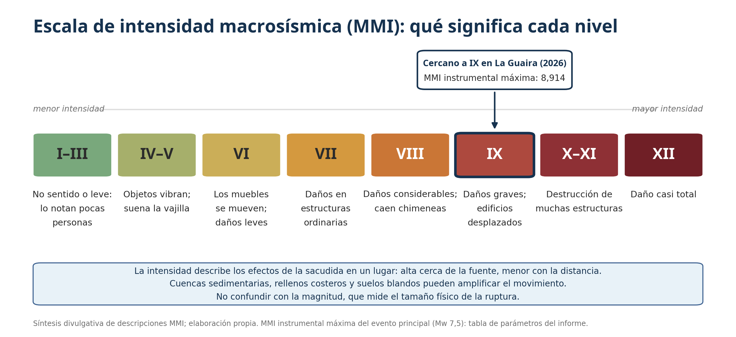
Figure 1. Macroseismic intensity scale (MMI) and associated effects; level close to IX recorded in La Guaira in 2026. Own elaboration.