
Block 02 of 11 · Report SSRC-TER-LG-01 · Version 2.2
The 24 June 2026 doublet and its damage
Instrumental sequence, chronology of the night, damage, aftershocks and cascading hazards.
5. The June 24, 2026 Doublet
| CENTRAL IDEA. Two large earthquakes separated by just over half a minute constitute an exceptional sequence for response: the second tremor arrives before the population and services can comprehend the first. |
|---|
| Parameter | First event | Second event |
|---|---|---|
| Revised UTC time | 22:04:31 | 22:05:03 |
| Magnitude | Mw 7.2 | Mw 7.5 |
| USGS Location | 20 km E of San Felipe | 17 km W of Catia La Mar |
| Coordinates | 10.3713°N; 68.5564°W | 10.6221°N; 67.1935°W |
| Depth | 10 km | 10 km |
| Maximum instrumental MMI | 8.806 | 8.914 |
| PAGER | Red | Red |
| Retrospective classification | Doublet precursor | Main event |
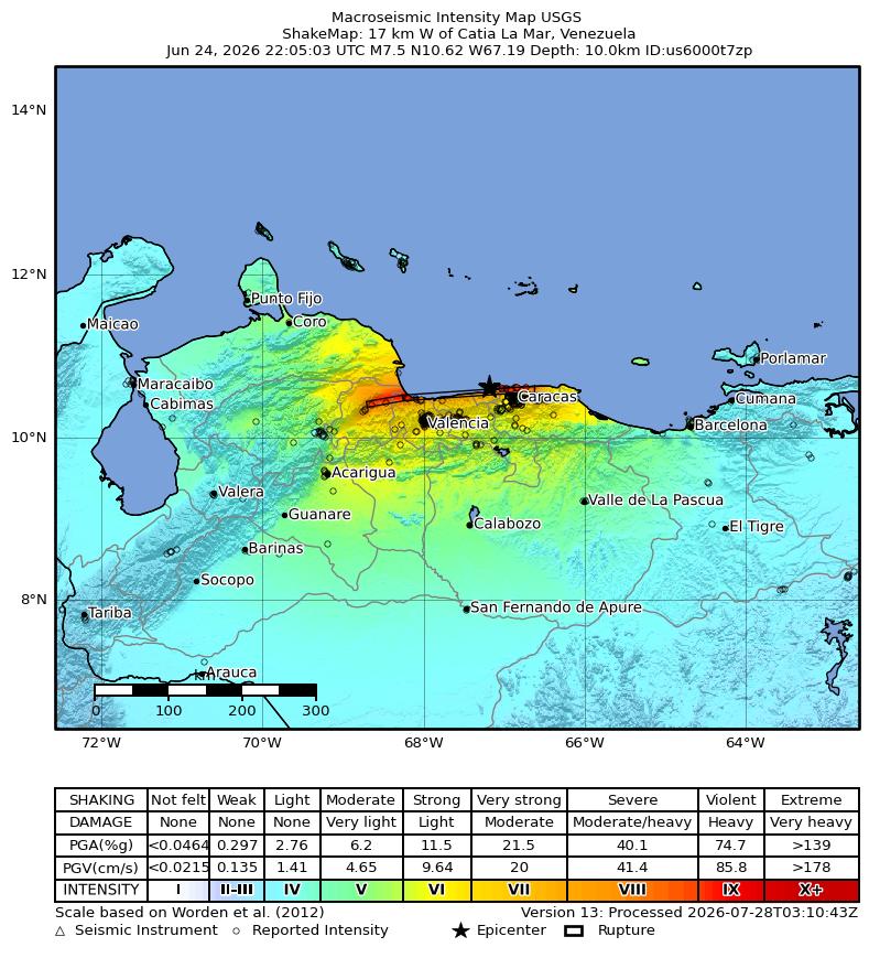
Figure 4. Intensity ShakeMap of the Mw 7.5. Source: USGS, public product consulted on August 8, 2026.
Rapid solutions for a large earthquake change as data from more stations arrive, and phases, mechanisms, and satellite deformation are revised. In the following days, different locations and time differences circulated. The revised record used here separates the hypocentres by about 150 km in an approximate east-west direction. The interval between origin times is 32.2 seconds. Some early pages retained the figure of 39 seconds: this is not a physical contradiction, but a trace of catalogue revisions.
The predominant mechanism was shallow strike-slip within the plate boundary zone. The shallow depth increased the shaking nearby. Rupture directivity, slip distribution, and the sequence of two sources explain why a simple epicentral point is insufficient: the damaging area is related to the entire rupture, not just a pin on the map.
Red PAGER indicates that the USGS rapid models considered high human and economic losses probable. It is not a count, but a probabilistic estimate based on intensity, population, and vulnerability. ShakeMap combines records and models to describe ground motion; it is updated with new information and must be identified by version.
During the first minute, individual priorities are to protect oneself from falls and falling objects. For the emergency system, the first hours require identifying collapses, fires, water cuts, damage to hospitals, bridges, ports, and airports, and potential tsunamis or landslides. A doublet increases the probability that structures damaged by the first event will fail with the second before being inspected.
5.1 Chronology of the night of June 24, 2026
The reconstruction that follows uses only the revised USGS record collected in section 5 and its associated products. Times are expressed in UTC, as in the rest of the report; in mainland Venezuela, they corresponded to 18:04 and 18:05 in the afternoon (UTC-4), at the end of the working day and with many families already at home or in transit.
At 22:04:31 UTC, the first rupture began: an Mw 7.2 earthquake located 20 km east of San Felipe (10.3713°N; 68.5564°W), at a depth of about 10 km. The shaking was intense in a wide strip of the north-central region: the estimated maximum instrumental intensity reached 8.806 on the Modified Mercalli scale, and the USGS PAGER system issued a red alert, meaning its rapid models considered high human and economic losses probable. In homes, the possible behaviour during that minute was that described in section 14: to protect oneself where one was, without running towards the exits.
Thirty-two seconds later —32.2 seconds in the revised solution—, at 22:05:03 UTC, a second rupture of Mw 7.5 magnitude began, located 17 km west of Catia La Mar (10.6221°N; 67.1935°W), also at a depth of about 10 km. Its estimated maximum instrumental intensity was 8.914 and it also received a red PAGER alert. The two hypocentres were separated by about 150 km in an approximate east-west direction. Only retrospectively can the first event be called a "precursor": at the time it occurred, no one could know that it was the announcement of a larger one.
Half a minute is not enough time to process anything. When the second tremor arrived, the population was still under tables, on stairs, or exiting to the street from the first shock; emergency services had not even received the first complete calls. Operationally, a doublet like this has three direct consequences. First: people who had survived the first event were trapped by the second when leaving already damaged buildings or re-entering others. Second: responders —neighbours, firefighters, health teams— were in the street, on ramps, and in access areas, exposed to facades, cables, and cornices when the second rupture occurred. Third: structures damaged by the first event withstood the second without prior inspection; as section 5 points out, a doublet increases the probability that buildings injured by the first tremor will collapse with the second. The predominant mechanism was shallow strike-slip, and the rupture directivity concentrated energy in certain directions: the damaging area corresponds to the entire rupture zone, not a single point on the map.
With the second event, the aftershock sequence described in section 6 began, with the local increase in activity that catalogues recorded in June. It should be remembered that the first versions of the catalogue gave different locations and a 39-second interval from the revised ones: this is not a contradiction, but the normal trace of refinement with more stations.
This chronology matters for two reasons. For research, it organises the questions: which buildings resisted the first event and failed with the second, what response decisions were made in a scenario that changed again after 32 seconds, and which victims correspond to each tremor. For families, it matters because it explains something that many experience with guilt or doubt: what happened that night was not an earthquake that could be "managed well"; there were two, chained before any person or institution could react. The speed of the sequence does not absolve anyone for what was done wrong afterwards, but it puts into perspective what was possible in that first minute.
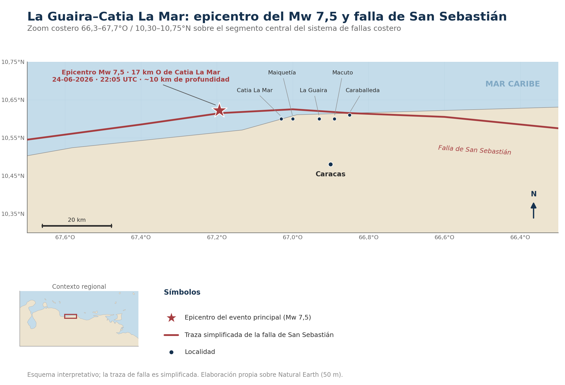
Figure 5. Detail of the La Guaira–Caracas corridor: simplified trace of the San Sebastián fault and revised location of the Mw 7.5. Own elaboration based on Natural Earth.
6. Damage, aftershocks and cascading hazards
| CENTRAL IDEA. After the main rupture, another emergency begins: aftershocks, rain, unstable slopes, leaks, fires, logistical disruption and exposure of people inside damaged buildings. |
|---|
Aftershocks are crustal readjustments in and around the disturbed zone. Their frequency usually decreases approximately over time, but the pattern is statistical: there can be quiet intervals and new strong events. A minor aftershock in magnitude can cause disproportionate damage if it is shallower, closer to a population, or strikes weakened structures.
La Guaira combines steep slopes and a narrow urbanised strip between the mountains and the sea. The USGS observed widespread landslides in the mountains above La Guaira and Naiguatá, damage or burial in Catia La Mar and Playa Grande, and possible communities isolated by the coastal road. The shaking leaves fractures, loose masses and changes in drainage. Subsequent rains can transform unstable material into debris flows similar, though not identical, to those that devastated Vargas in 1999 [3,28].
Technological hazards include fires due to gas or electricity, fuel spills, tank failures, contamination of water intakes, loss of refrigeration, telecommunications outages and congestion. In ports and airports, small deformations can render pavements, cranes, pipelines or navigation systems unusable even if the structure appears to be standing.
Management must prevent "emotional return" to damaged properties. A tag or preliminary inspection does not equate to rehabilitation. Non-structural elements - facades, false ceilings, shelving, tanks, equipment - cause numerous injuries. Reopening decisions require competent professionals, aftershock monitoring and clear evacuation routes.
The human dimension evolves. As of August 3, the official toll cited by Reuters was 6,125 fatalities and nearly 61,000 hospital attendances [8]. A distinction must be made between confirmed deaths, missing persons, injured, treated, displaced and homeless people. Adding categories or comparing temporary snapshots without a date generates misinformation.
Priority impact chain
Strong shaking and structural/non-structural failures.
Aftershocks aggravating damage and endangering rescuers.
Landslides and rockfalls isolating communities.
Ruptures of water, sanitation, gas, electricity and fuel lines.
Contamination, lack of safe water and sanitary pressure.
Rain on fractured slopes and delayed generation of flows.
Prolonged displacement, post-traumatic stress and social deterioration.
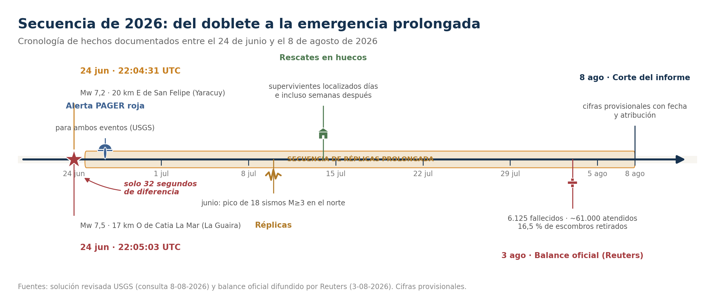
Figure 6. 2026 sequence: from the June 24 doublet to the prolonged emergency. Own elaboration.
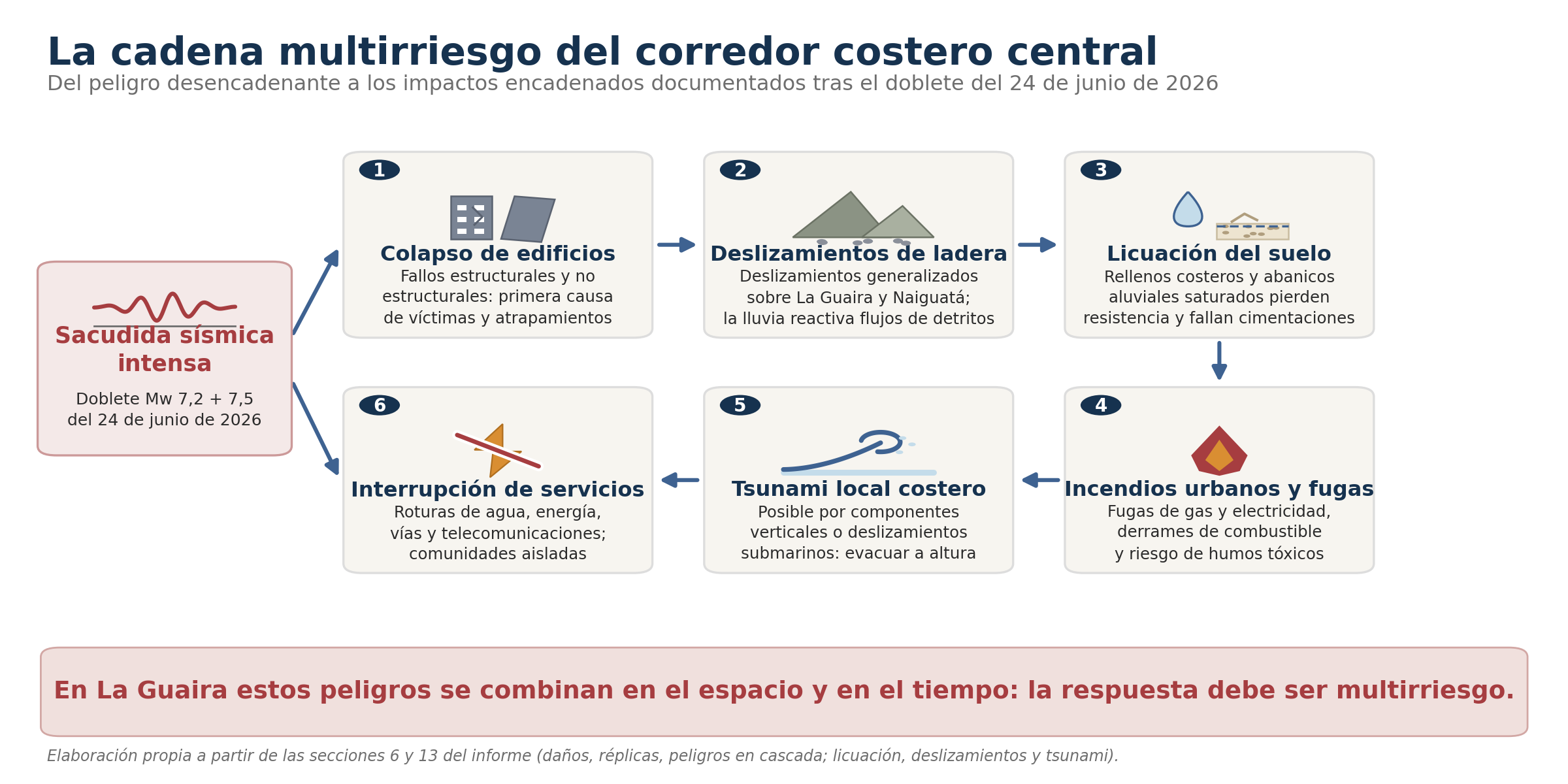
Figure 7. Multi-hazard chain of the central coastal corridor. Own elaboration.