
Block 10 of 11 · Report SSRC-TER-LG-01 · Version 2.2
Evidence, memory, microzonation and questions
Matrix of evidence, memory and memorial, seismic microzonation and frequently asked questions from families.
26. Evidence matrix for photographs, networks and testimonies
Network research is valuable for locating facts, sequences and witnesses, but it is vulnerable to old images, erroneous locations, impersonator accounts, editing and circular repetition. Each piece must retain its URL, author, publication date and, if legally obtainable, original file and metadata. Verification seeks geolocation through facades, relief, signs and shadows; chronolocation by weather, light, aftershocks or transmissions; reverse comparison; and independent corroboration.
| Class | Meaning | Permitted use |
|---|---|---|
| A - Confirmed | Competent primary source and traceable evidence | Direct factual assertion |
| B - Corroborated | Two or more consistent independent sources | Prudent conclusion |
| C - Testimonial | Identifiable account, not yet materially corroborated | Attributed narration |
| D - Indicative | Plausible image or publication with gaps | Research hypothesis |
| E - Refuted or incompatible | Date, place or content contradicted | Do not use except to explain misinformation |
In particular, claims about structural EPS, delayed rescues, casualty numbers, looting, responsibilities and service failures require a high standard because they affect reputations, processes and grief.
27. Memory, Truth, and Memorial: The Right of Families to Know
27.1 A Dignified and Verifiable Register as a First Act of Justice
Section 18.2 defined victim registration as a critical operation; this section places it where it belongs: as a right. Knowing what happened to a person—where they were, when they were located, how they were identified—is not an administrative courtesy, but the condition for mourning, for civil procedures, and for any subsequent claim. A dignified register distinguishes confirmed fatalities, missing persons, persons located alive, and displaced persons; it avoids duplication with unique identifiers; it records who confirmed each piece of data, when, and with what document; and it keeps each figure dated with its source. That a person remains in the missing category is neither a minor nor a provisional detail: it is a status that demands active search and periodic communication with their family.
Technical truth is part of the same right. Families have the right to know why the building where their loved ones died collapsed: what materials were used, what regulations were in force, what inspections existed, and what warnings were ignored. This truth is constructed using the method described in section 19.3—evidence with chain of custody, tests, signed expert reports—and communicated without euphemisms or unsubstantiated accusations. A rigorous investigation does not reopen grief: it provides a foundation for it to rest upon.
27.2 A Community Disaster Archive
The memory of a catastrophe is quickly lost if it is not deliberately archived. A community archive of the 2026 disaster should gather, with clear verification criteria:
Photographs and videos with date, location, author and, where possible, original file and metadata, applying the evidence matrix from section 26.
Testimonies collected with informed consent, identifying the witness, their observation conditions, and the moment of the account.
Technical files: plans, expert reports, tests, inspection reports, and emergency decisions, preserved before debris removal or staff rotation disperses them.
Local chronologies: what happened in each building, neighbourhood, or institution, hour by hour, with cross-referenced sources.
The archive needs access rules that protect privacy: images of victims, medical records, and family accounts are not published without consent, as established in section 18.2. And it needs institutional custody—universities, libraries, museums, victims' associations—so that it does not depend on the memory of a single generation. Archives of previous earthquakes show what is lost when no one takes custody: of the great historical Venezuelan earthquakes, only chronicles and debates about magnitudes remain, when from each one there could have been an inventory of damages capable of guiding subsequent construction.
27.3 Remembering Saves Lives: Memorials, Education, and Mourning
Section 4 concluded with a warning: social memory shortens faster than the tectonic cycle. A memorial is not just a tribute; it is a prevention tool. Communities that preserve signs, accounts, and education about their disasters recognise danger signs earlier, demand building codes, and participate in drills. An effective memorial combines three elements: the name and dignity of those who died, an honest explanation of why it happened, and the conduct that must be adopted to prevent it from happening again—evacuation routes, meeting points, demand for inspection.
This public narrative must be balanced with private mourning. Not all families want their loved ones' names to appear on a plaque or in a documentary; consent also governs memory. Memorials are built with families and the community, not upon them, in line with section 18.3, and leave space for both individual remembrance and collective pedagogy. Ultimately, memory and technical truth pursue the same goal: that the knowledge that cost lives be incorporated into how we build, plan, and respond, and that no future family has to reconstruct from scratch the questions that these families have already asked.
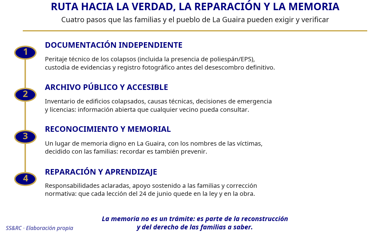
Figure 21. Path to truth, reparation, and memory: four steps demandable and verifiable by families and the community. Own elaboration.
28. Seismic microzonation and land-use planning: the map La Guaira needs
28.1 What is microzonation and how is it obtained?
Regional seismic hazard indicates how much a fault can shake; microzonation indicates how each neighbourhood responds. Two identical buildings separated by a few hundred metres can experience very different shaking because the ground beneath them modifies the waves: soft sediments and fills amplify certain frequencies, slopes and ravine edges concentrate them, and saturated deposits can liquefy, as shown in section 13. Microzonation translates this into urban-scale maps.
The study combines several established techniques. The shear wave velocity in the upper 30 metres (Vs30) classifies the ground from rigid rock to very soft soil and forms the basis of most design regulations. Microtremor tests —measurement of permanent ambient vibration using the H/V or HVSR method— estimate the predominant period of each site without the need for extensive campaigns. Geotechnical boreholes and tests complete the subsurface model. The result is neighbourhood maps of expected amplification, liquefaction susceptibility, slope stability and, on the coast, tsunami inundation zones: the information that determines where a building must be more demanding of itself and where it should not exist.
28.2 Why the La Guaira-Caracas corridor demands it
Few urban strips concentrate so many site effects in such a small space. La Guaira occupies a narrow coast between the Cordillera de la Costa and the sea, with coastal fills, alluvial fans of ravines, steeply urbanised slopes, and access routes that can be interrupted by landslides, as described in section 6. The 1967 earthquake already provided a warning: the deposits of the Caraballeda fan showed evidence of liquefaction, and the city registered local amplifications that explained part of its collapses, as recalled in section 4. That lesson is almost sixty years old and still lacks a map to translate it into plot-by-plot decisions.
Caracas adds its own conditions: sedimentary basins under densely populated areas, growth on slopes, and a critical infrastructure network that crosses sectors with very different responses. Without microzonation, the design standard is applied as if the ground were uniform, which it is not; and land-use planning decides uses without knowing what ground lies beneath.
28.3 From map to planning: use, funding and governance
A microzonation that does not change decisions is an archived document. Its conversion into planning implies, at a minimum:
Defining where to rebuild and where not to: exclusion or restriction of construction in areas of severe liquefaction, ravine channels with debris flows, unstable slopes and tsunami strips, with orderly relocation where appropriate.
Adjusting rehabilitation regulations by zone: differentiated reinforcement requirements according to amplification and soil, in coordination with the COVENIN 1756 standard, and mandatory inspection of existing buildings in sectors of highest amplification before any change of use or extension.
Incorporating maps into licenses, cadastres and emergency plans, so that each permit cites the ground condition and each response plan knows its critical sectors.
The funding for such a study is modest compared to the cost of a single collapse: it can be articulated with public reconstruction funds, international cooperation, and regional scientific programmes. Governance matters as much as money. The study needs technical leadership from FUNVISIS and Venezuelan universities —which possess the country's seismic and geotechnical tradition—, funding and official adoption by national, regional and municipal governments, open data with dated versions, and community participation to validate local observations. The first 100 days and the first year of the programme in section 25 already foresee priority microzonation and geotechnical studies: this section specifies that it is not just another line item on the timeline, but the map upon which almost all other reconstruction decisions depend.
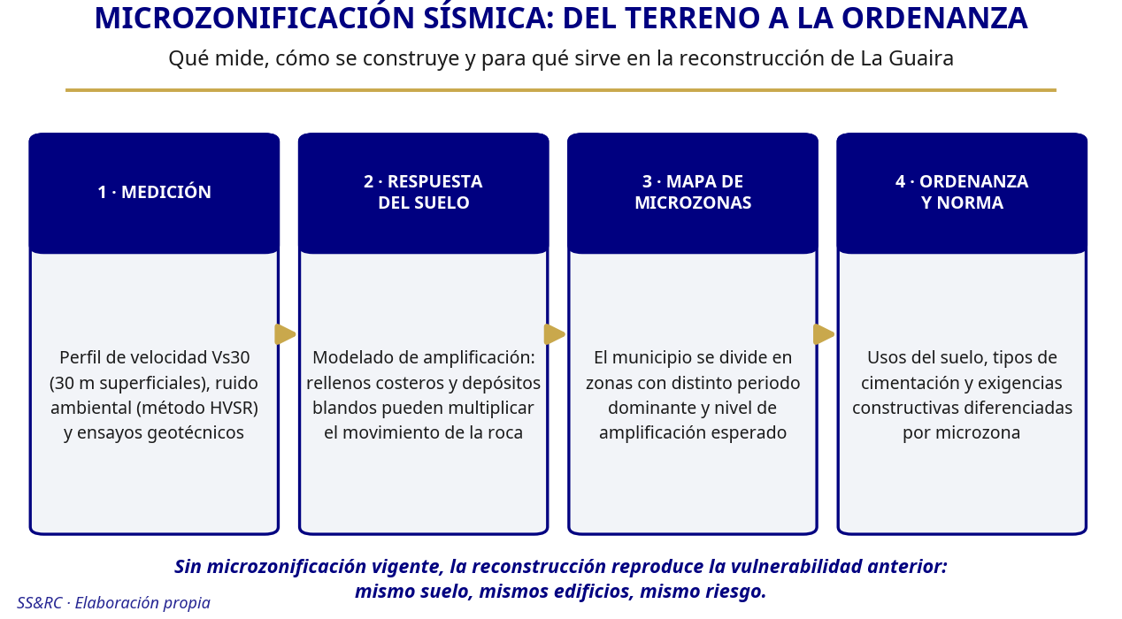
Figure 22. Seismic microzonation: from ground to ordinance, in four steps. Own elaboration.
29. Frequently Asked Questions from Families and the Community
Can such an earthquake recur in La Guaira?
Yes, a major earthquake can occur again in northern Venezuela, although no one can say when. The Caribbean-South American plate boundary, with the Boconó-San Sebastián-El Pilar fault system, has produced large earthquakes throughout history: 1812, 1900, 1967, 1997, and now 2026 (see sections 3 and 4). Current science does not allow for the prediction of date, location, and magnitude; it allows for understanding the hazard and reducing vulnerability. The useful question is not "if it will recur," but rather which buildings, slopes, and services will be best prepared when it does.
How long will the aftershocks last?
Aftershocks will continue for months and their frequency will decrease, but the pattern is statistical: there may be quiet pauses followed by a strong aftershock. A minor aftershock in magnitude can cause significant damage if it strikes already weakened structures (see section 6). In June 2026, M≥3 earthquakes detected in northern Venezuela increased from 4 to 18, a local increase typical of an aftershock sequence, not a regional change (see section 7). It is advisable to maintain self-protection measures until the seismic authority confirms stabilisation.
Is it safe to return to my building?
Do not return until competent professionals have inspected it. A tag or preliminary inspection is not equivalent to rehabilitation, and the "emotional return" to damaged properties is a documented risk, especially with aftershocks (see section 6). Reopening decisions require structural evaluation, not just a glance at the façade: many dangerous damages are in columns, joints, or foundations and are not visible. In the meantime, use the visual inspection checklist in Annex B only as guidance and never as authorisation.
What should I do if I see new cracks?
Cordone off the area and keep people away if there are serious signs: cracks crossing columns or beams, leaning walls, doors that no longer close, subsidence, breaking sounds, or concrete spalling. Cracks can have several causes—tectonic deformation, settlement, liquefaction, landslide—and their interpretation requires a professional (see section 12). Document with dated photographs, do not enter if the structure is unstable, and notify the building inspection authority and civil protection. On slopes, new cracks with leaning trees or new springs are an immediate warning sign (see section 13).
Is the polystyrene I found in the rubble illegal?
Not necessarily. Expanded polystyrene (EPS) is a legitimate technique in lightweight slabs, insulation, and infills when the project specifies it and the resistant concrete is complete (see section 19.3.1). It is an indication of irregularity if it occupied the volume of columns, beams, joints, walls, or support areas, where it should never appear (see section 19.3.2). Do not publicly assert it as fraud: photograph it with scale and reference, do not move it if it could be evidence, and hand it over to the chain of custody for expert assessment (see section 19.3.3).
Where do I report deficient construction or irregular work?
To the municipal urban control and building inspection authority and, if there is imminent risk, to civil protection. Provide concrete data: address, dated photographs, description of the deficiency, and, if available, the file or permit for the work. Reports of deficient materials and execution require a high standard of evidence because they affect people and processes (see sections 19.3 and 26). Associations of affected persons can also request independent expert assessment and access to files, as detailed in section 19.3.4.
How do I register a missing family member?
Go to the official register of missing persons enabled by the emergency authorities and to the information point in your area or shelter. Provide full name, identification document, recent photograph, last known location, distinguishing marks, and relevant medical data, and demand proof of registration with date and number. Distinguish between categories: missing is not deceased (see section 18.2). Keep your contact details updated and consult only official channels; unverified lists on social media generate duplicates and false hopes (see section 17).
What psychological support is available and why is it important?
Loss, entrapment, and uncertainty produce intense reactions—insomnia, guilt, anxiety, intrusive memories—which in many cases are expected responses, not illness (see section 18.3). The most useful initial aid combines safety, reliable information, contact with support networks, and continuity of usual medication; clinical attention is appropriate when there is risk to the person or persistent deterioration. Look for psychosocial support points in shelters and health centres, and the quiet spaces provided in reception facilities (see sections 18.3 and 21.5). Asking for support is not weakness: it is part of disaster treatment.
My well water changed after the earthquake. Is it dangerous?
Wells respond physically to earthquakes: they can rise, fall, become turbid, or change in smell and temperature, and most return to their normal state (see section 11). The immediate risk is not the change itself, but contamination: broken sanitation, cracks, or loss of pressure can introduce wastewater. If there is turbidity, odour, or damage to the wellhead, suspend consumption, use alternative supply, and notify the water and public health authority for analysis and disinfection (see sections 11 and 23.1). An altered well does not announce another earthquake: do not spread unvalidated prediction messages.
Can there be a tsunami in La Guaira?
Yes, it is possible: a coastal or submarine earthquake can generate a tsunami if it vertically displaces the seabed or triggers a submarine landslide, and strike-slip faults like those of 2026 do not completely rule it out (see section 13). The self-protection rule is simple: if you are by the sea and the shaking is strong or lasts around 20 seconds or more, protect yourself during the movement and, when it ends, walk to high ground without waiting for official confirmation. Know your neighbourhood's pedestrian evacuation routes in advance, because in La Guaira, narrow access points can become blocked (see section 14).
What is the AAAC proposed in the report?
It is the Autonomous Reception and Continuity Area (AAAC, from its Spanish acronym): a previously studied, equipped, and maintained plot of land that normally functions as a park or sports area and, after a catastrophe, becomes a reception centre with its own water, sanitation, solar energy, health post, temporary school, kitchens, and communications (see section 21). It is not an improvised camp or indiscriminate evacuation: it accommodates those who cannot safely remain in their homes, preserving neighbourhood units and support networks. Its pilot construction is among the measures for the first year of the programme in section 25.
How can I participate in the reconstruction with voice and vote?
You have concrete channels: associations of affected persons and communal councils, the technical and community committee planned for the first 100 days, expert assessments with the participation of experts proposed by the associations (see section 19.3.4), and the public reconstruction observatory, which must publish inspections, contracts, maps, and progress (see section 24.2). You can also join community brigades, drills, and local validation of microzonation (see sections 25 and 28). Organised participation is not a favour: it is the mechanism that converts the lessons of 2026 into verifiable decisions.
Complementary Development Sources
International Search and Rescue Advisory Group (INSARAG), Guidelines and technical notes for urban search and rescue: https://insarag.org/methodology/insarag-guidelines/
Ministry of Land, Infrastructure, Transport and Tourism of Japan, disaster prevention park program: https://www.mlit.go.jp/toshi/park/toshi_parkgreen_tk_000134.html
FEMA, National Urban Search and Rescue System: https://www.fema.gov/emergency-managers/national-preparedness/frameworks/urban-search-rescue
USGS, Mw 7.5 event of 24 June 2026 and associated products: https://earthquake.usgs.gov/earthquakes/eventpage/us6000t7zp/executive
USGS, landslide hazards of the 2026 Venezuelan sequence: https://www.usgs.gov/programs/landslide-hazards/science/2026-venezuela-sequence-earthquake-triggered-landslide-hazards
UNDRR, integration of risk reduction and environment in shelter responses: https://www.undrr.org/news/strengthening-risk-informed-humanitarian-shelter-through-drr-and-environment-integration-undrr
CDC, safety during and after an earthquake: https://www.cdc.gov/earthquakes/safety/stay-safe-during-an-earthquake.html
INSARAG, post-earthquake review of Türkiye and Syria 2023: https://insarag.org/aar-turkiye/