
Block 01 of 11 · Report SSRC-TER-LG-01 · Version 2.2
Southern Caribbean Tectonics and Seismic History
Caribbean-South America plate boundary, fault system, and the seismic history of Venezuela and La Guaira.
3. Tectonic Setting of Venezuela and the Southern Caribbean
| CORE IDEA. The Caribbean-South American boundary is not a single line: it is a deformed zone tens to hundreds of kilometres wide with main faults and secondary structures capable of distributing deformation. |
|---|
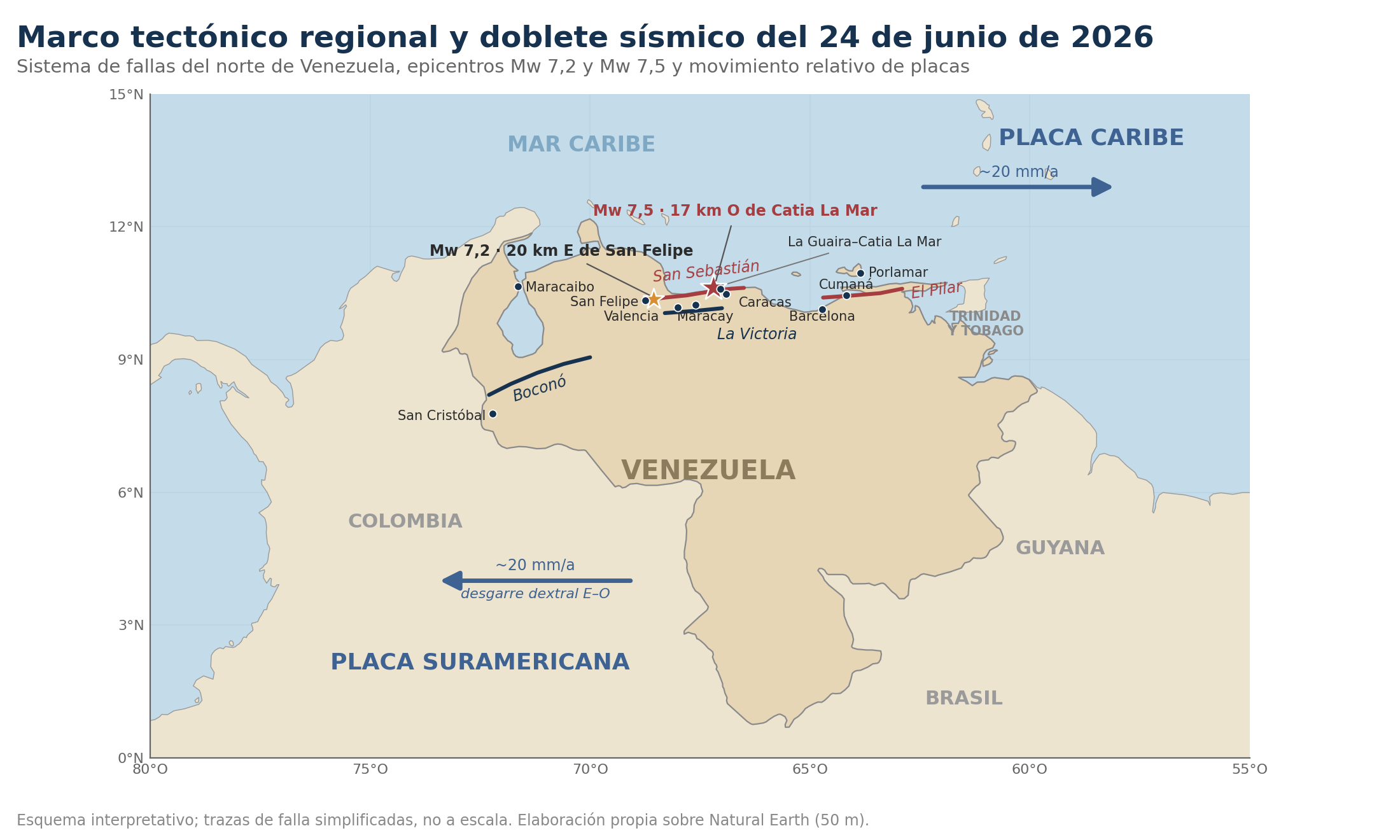
Figure 2. Regional tectonic scheme and revised locations of the 2026 doublet. Own elaboration with USGS data; simplified fault traces.
The Caribbean Plate moves approximately eastward with respect to South America. This movement is absorbed by dextral strike-slip faults, folds, thrusts, and distributed deformation. The Boconó-San Sebastián-El Pilar system constitutes the best-known axis: Boconó crosses the Venezuelan Andes, San Sebastián continues through the north-central region and coast, and El Pilar dominates the east.
The San Sebastián fault runs largely offshore, parallel to the Cordillera de la Costa and close to densely populated centres. Its submarine geometry complicates detailed understanding and opens debates about the source of historical earthquakes, such as that of 1900. The La Victoria, Tacagua-El Ávila, Oca-Ancón faults and numerous minor structures contribute to a complex deformation field.
To the east, the South American lithosphere subducts beneath the Lesser Antilles arc. This generates earthquakes from shallow to deep beneath the eastern Caribbean and insular volcanism. In Trinidad and the Gulf of Paria, crustal faults, prism deformation, and seismicity related to the subducted plate overlap. To the west, interaction with the North Andes microplate and Nazca subduction increases complexity in Colombia.
The hazard in northern Venezuela is not limited to a single traced fault. A rupture can jump or transfer stress between segments, and strong ground motions propagate through basins and urban corridors. The 2026 doublet, with two large events separated by seconds, illustrates a rapid interaction between nearby sources. The designation "foreshock" for the first event is only possible retrospectively, after the larger event has occurred.
4. Seismic History of Venezuela and La Guaira
| CORE IDEA. Quiet periods between disasters do not equate to an absence of danger. Venezuelan history contains destructive ruptures separated by decades or centuries. |
|---|
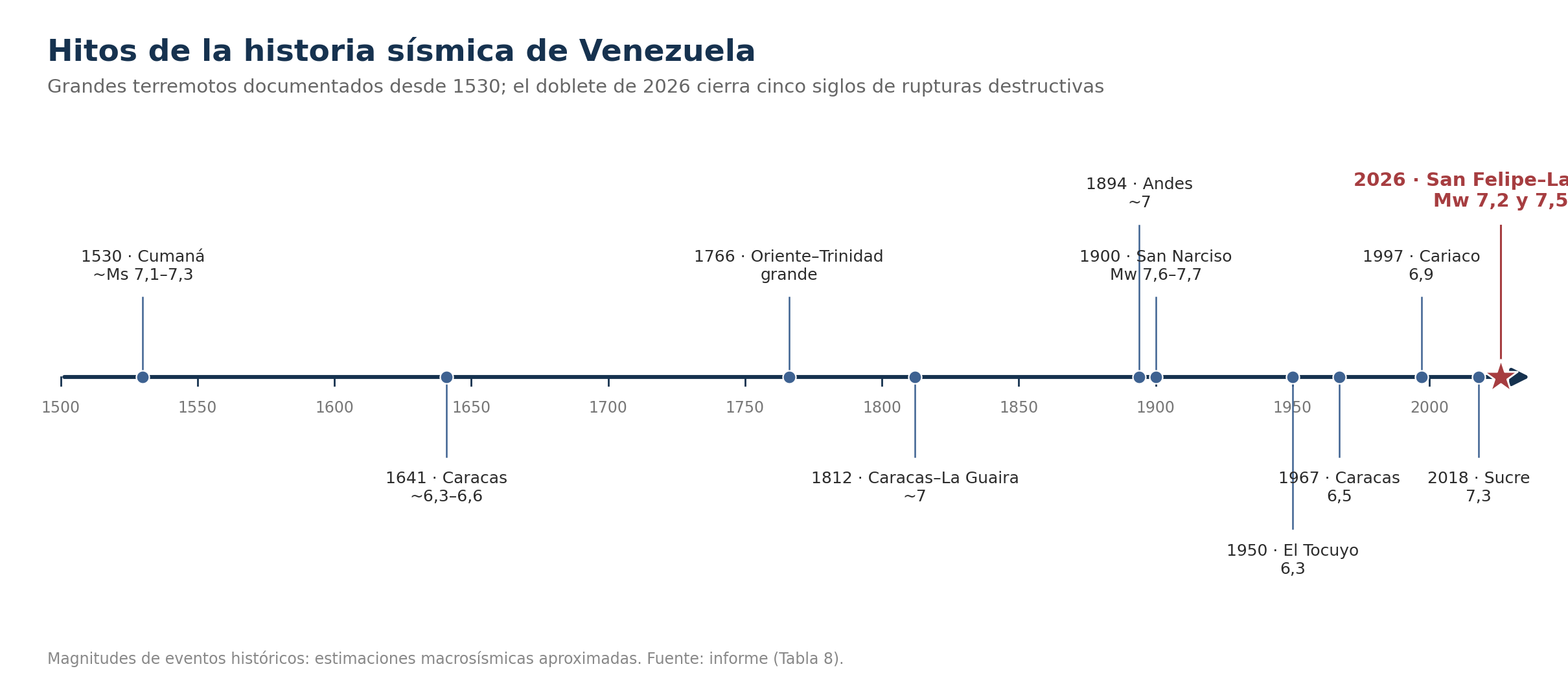
Figure 3. Selection of seismic milestones; magnitudes of historical events are estimates and may vary between catalogues.
The 1530 earthquake in Cumaná is one of the first documented and was associated with marine disturbances consistent with a tsunami. Palaeoseismic and historical studies of the El Pilar system show that the association of ancient events with specific segments retains uncertainty, but confirm a history of large ruptures in eastern Venezuela [25].
In 1641, Caracas suffered significant destruction. The great earthquake of 1766 affected an enormous area of Venezuela and the Caribbean; its depth and source have been debated. In 1812, a destructive sequence struck Caracas, La Guaira, Barquisimeto, San Felipe, and Mérida in the context of the War of Independence. Traditional figures of tens of thousands of victims for the entire episode should be handled with caution: documentary studies estimate about 2,000 fatalities in Caracas and show how construction, conservation, and political biases altered the accounts [27]. FUNVISIS (Venezuelan Foundation for Seismological Research) recalls about 4,000 deaths in La Guaira.
The 1875 Cúcuta earthquake affected the Colombian-Venezuelan border; the 1894 Andes earthquake damaged Mérida and towns in the west. On October 29, 1900, the San Narciso earthquake shook Caracas and the north-central coast. Modern studies place its magnitude approximately between Mw 7.6 and 7.7 and maintain the debate between the La Tortuga and San Sebastián faults [26].
In 1950, El Tocuyo suffered an approximate Mw 6.3; in 1967, Caracas experienced an earthquake of around 6.5 that caused collapses and revealed local amplifications. Deposits of the Caraballeda fan showed evidence of liquefaction. On July 9, 1997, the Mw 6.9 Cariaco earthquake caused deaths, severe damage, and surface rupture in El Pilar. In 2009, an Mw 6.2 affected Carabobo, and in 2018, an Mw 7.3 near Carúpano was widely felt.
The historical lesson is twofold: the northern strip has produced large earthquakes, and damage recurs where unfavourable soils and vulnerable buildings converge. Social memory, however, shortens faster than the tectonic cycle. Each generation tends to consider a phenomenon exceptional that geology understands as recurrent, though not periodic.
| Date | Area | Approximate Magnitude | Main Observation |
|---|---|---|---|
| 01-09-1530 | Cumaná | ~Ms 7.1-7.3 | Damage and historical tsunami; probable submarine source. |
| 11-06-1641 | Caracas | ~6.3-6.6 | Colonial destruction; no instrumental information. |
| 21-10-1766 | East/Trinidad | Large, debated | Enormous felt area; possible intermediate depth. |
| 26-03-1812 | Caracas-La Guaira-west | Sequence ~7 | Multi-city catastrophe; historical figures disputed. |
| 28-04-1894 | Andes | ~7 | Severe damage in Mérida and the west. |
| 29-10-1900 | North-central coast | Mw 7.6-7.7 | San Narciso; La Tortuga/San Sebastián source debated. |
| 03-08-1950 | El Tocuyo | 6.3 | One of the most destructive of the Venezuelan 20th century. |
| 29-07-1967 | Caracas | 6.5 | Collapses, local amplification, and liquefaction in Caraballeda. |
| 09-07-1997 | Cariaco | 6.9 | El Pilar rupture; severe school damage. |
| 21-08-2018 | Sucre | 7.3 | Deep earthquake/moderate relative impact, regionally felt. |
| 24-06-2026 | San Felipe-La Guaira | 7.2 y 7.5 | Doublet, intensity close to IX and national catastrophe. |